
Land surveyors pride themselves on their measurements. After all, what would be the purpose of commissioning a land survey if the bearings, distances, and areas on the map were not correct? But the simple fact is that no measurement is perfect. So the real question is not “is the survey accurate?” – but instead “how much error is contained in each measurement?” As any good lawyer would respond: it depends!
What is a Land Survey
A land survey is a detailed examination and measurement of a specific area of land to determine its boundaries, dimensions, and features. Professional surveyors employ various tools, such as GPS, total stations, and theodolites, to accurately map the terrain. The survey results are documented in a legal document known as a survey plat or map, which includes information on property lines, easements, and topographical details. Land surveys are crucial in real estate transactions, construction projects, and property development, ensuring that land is used appropriately and disputes over boundaries are minimized. They play a vital role in maintaining property rights and preventing conflicts.
Different Types of Land Surveys
Land surveys are crucial for understanding and mapping the Earth’s surface. Various types of land surveys serve different purposes in diverse fields.
- Boundary surveys determine property lines, preventing disputes.
- Topographic surveys capture natural and man-made features for construction and development.
- ALTA/NSPS surveys focus on commercial properties, considering title issues. Construction surveys guide builders with precise measurements.
- Floodplain surveys assess flood risks and compliance.
- Geodetic surveys establish reference points for mapping.
- Subdivision surveys divide land into lots for development.
Each survey type employs specialized techniques like GPS, total stations, and aerial imagery. Collectively, these surveys contribute to informed decision-making in land use, development, and resource management.
Accuracy vs Precision
Any discussion like this must begin with the description of accuracy vs precision. Most people use the terms “accuracy” and “precision” interchangeably. This is very dangerous. Accuracy refers to how closely a measurement or observation comes to measuring a “true value.” For example, the true length of a line is 100 feet, but your surveyor’s chain measures 100.02 feet. Pretty accurate. Precision on the other hand refers to how closely repeated measurements or observations come to duplicating measured or observed values. For example, you take five measurements of the same line: 91.00, 92.00, 91.50, 92.50, 95.00. You did an awful job!
From Clark: “A surveyor, with original field notes in hand, is required to search for all of the evidence of the original monument and its accessories in order to identify the original corner point. This has led courts to hold when one finds an original monument. As described in the official record, in unalterable and unchangeable.”
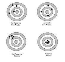
Figure 1: Accuracy vs. Precision Targets
Surveying Instruments
Once the discussion of accuracy vs precision is out of the way, now let’s talk surveying equipment. Land Surveyors are expert measurers and the evolution of land surveying equipment technology over the past 30 years is hard to imagine. We have gone from mechanical angle measurement devices and hand-pulled 100-foot tapes to digital devices with built-in microprocessors and lasers that measure distances. But even today, land surveying equipment can only measure to a certain accuracy. Total Stations and Global Positioning Systems (“GPS”), the two primary instruments used by surveyors today, both have limitations to their accuracy and precision because of a variety of random errors and systematic errors that occur with every survey measurement in the field.
Surveying errors combine to create an “ellipse of uncertainty” around every measured survey point. The size of this “cone of uncertainty” varies based on the precision of the equipment used, the conditions of the environment (temperature and humidity), and the amount of care that the surveyor used during data collection.
Imagine surveying the same line with a 1815 compass with an angular precision of 1 degree, a 1915 theodolite with an angular precision of 1 minute (1/60 degree), and a 2015 total station with an angular precision of 1 second (1/3600 degree). You are surveying the same line, at the same date and time, with the same survey crew. But with each upgrade in equipment, the precision of the angle increases exponentially. This is exactly what happens when surveyors retrace “old” survey maps and deeds.
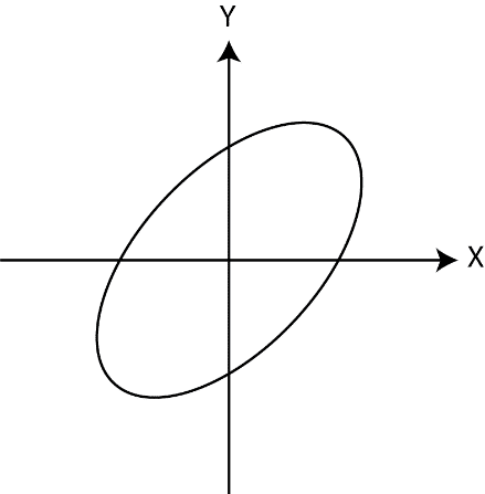
Figure 2: Error Ellipse
The point is at the center of the two intersecting lines and the possible location of the point due to error is somewhere within the circle.
Expressing Accuracy and/or Precision as a Number
Surveyors can estimate their precision using: (1) a ratio of closure that is required by State Rules for any boundary survey and (2) a relative positional precision that is required by ALTA survey standards. A ratio of closure is nothing more than a ratio between the error of the survey and the total distance of the parcel. Here, the parcel’s perimeter measures about 1,128 feet and the minimum ratio is 1:10,000. So, a survey is allowed to have 0.1128’ (2cm + 50 parts per million) of error within it. Chuck Ghilani’s Elementary Surveying is a great resource for learning more about this topic.
Ensuring Accuracy in Surveying
Accurate land surveying is paramount for various reasons, playing a crucial role in urban planning, construction, and property delineation. Precision in survey measurements ensures that boundaries are precisely defined, minimizing disputes over land ownership. In construction projects, accurate survey data aids architects and engineers in designing structures that align with legal property boundaries, preventing encroachments and legal conflicts. Additionally, precise land surveying is essential for infrastructure development, as it provides accurate topographical information crucial for designing roads, utilities, and drainage systems. Overall, the importance of accuracy in land surveying cannot be overstated, serving as the foundation for responsible and sustainable development while safeguarding property rights and minimizing legal complications
To learn more about surveying measurements, their meta data and how topics like these may affect your boundary dispute, contact Tony Nettleman at www.cnettleman.net

