
Deeds – contracts for the sale, lease, and mortgage of real property – are essential elements in any land transaction because real property conveyances are required by law to be in writing. But what’s the size, shape, and location of the parcel? That’s the job of a well-written legal description.
Legal descriptions come in many forms: Public Land Survey System descriptions, Metes & Bounds descriptions, Lot & Block descriptions, and my favorite, Calls to Adjoiners (a sub-type of Metes & Bounds). Below are two examples.
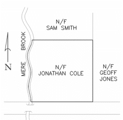
Figure 1: The Johnson Tract. "Bounded on the West by Mere Brook, Bounded on the North by Smith, Bounded on the East by Jones, and Bounded on the South by Main St."
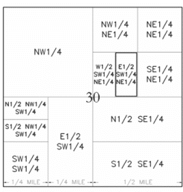
Figure 1: The Johnson Tract. "Bounded on the West by Mere Brook, Bounded on the North by Smith, Bounded on the East by Jones, and Bounded on the South by Main St."
Sometimes the legal description will be a mix of different formats. For example, “beginning at the NW ¼ corner of section 30, thence 30° 452.50 feet.” Can you correctly choose which two systems were used?
The type of legal description format (PLSS vs Metes & Bounds, etc.) will depend on the area of the country, the state where the land is located and the time period when the parcel was created. No matter the type, a few important principles governs the interpretation of the description.
First, the correct “type of north” must be used when plotting the legal on a computer or retracing the legal in the field. There are many types of north but the most common are astronomic north that is found by observing Polaris, grid north which is a fictious projection and magnetic north which points towards the magnetic north pole. In central Missouri, magnetic north has varied from +8° to -2°. Magnetic north was used exclusively until the early 19th century, when the US Government began requiring solar observations to be conducted. Be careful that you use the correct north when interpreting any legal description!
Second, extrinsic evidence is only allowed in a certain number of states. Imagine part of legal description read “In Tarrant County, Texas…Beginning at Jeb’s Landing, thence…” Who is Jeb and where is his landing (i.e. ferry landing)? If the state or federal court allows extrinsic evidence, then a historical map could easily show us where to begin. But without a vicinity map or other identifying information, courts that exclude extrinsic evidence could rule this description void. When in doubt, always overexplain the location, size, and shape of the parcel when authoring a new legal description to avoid the possibility of the description being declared void.
Third, there is no such thing as a perfect description, so the priority of calls is used to create a “hierarchy” of calls. For example, in the description, a call reads “Thence North 150.00 feet to a rebar.” During your field survey, you find the rebar, but it is actually N 00-00-05° 150.10. Very close, but there is still a conflict. The priority of calls states that bearing/distance yields to field monuments, so when you write the new legal description, it will be “Thence N00-00-05° 150.10 feet to a rebar.” You hold the rebar. Surveyors, attorneys, and property owners have ignored the priority of calls at their own peril, don’t be one of them.
Finally, appreciate the difference between having the power to do something versus the competence to do it well. In some states, only land surveyors can author legal descriptions. But in many other states, attorneys, land owners, or just about anyone can author a description. Just because you CAN do something doesn’t mean you should. If you’re a fantastic litigator and just won the big property case, would it behoove you to let your expert surveyor write the description to be included in the court’s final order?

